We Waited Five Years to Drive the Apache Trail. It Did Not Disappoint.

Have you ever had a deep connection to a place that was lost to time, development, or nature’s unpredictability?
That’s how I felt when a rockslide closed the Apache Trail in 2019.
And for five years, this 40-mile stretch through the Superstition Mountains sat behind barricades.
Every time we drove past the closure, we’d wonder if we’d ever get to see it. The loss felt personal, like a piece of Arizona had been cut off, locked behind piles of debris and bureaucracy.
When it finally reopened, we didn’t wait long to get out there. And trust me, it’s not just another scenic drive.

Tracing the Path of Stagecoaches and Settlers
The Apache Trail, also known as State Route 88, is a road that runs straight through Arizona’s past.
Long before cars existed, the Apache used this route to navigate the Superstition Mountains. Later, it became a supply line for workers hauling materials to build the Roosevelt Dam.
The road was rough, narrow, and dangerous, and over a century later, not much has changed.

We started our drive at Roosevelt Lake, the largest body of water located entirely within Arizona. Roosevelt Dam, built between 1905 and 1911, made it possible.
It tamed the Salt River, providing flood control, hydroelectric power, and a water supply that let Phoenix explode into the sprawling city it is today.
After passing the dam and winding along the Salt River, we hit a construction zone. Water trucks sprayed the road to keep the dust down while crews wrapped up repairs. The road might be open, but ADOT isn’t finished with it yet.
Eventually, the pavement disappeared, and the real adventure began.
Some roads ease you into their wildest sections. The Apache Trail doesn’t believe in warm-ups. Not long after the pavement ends, the cliffs start closing in, and you realize just how little room there is between your tires and the drop-off

Fish Creek Hill (AKA The White-Knuckle Section)
Every great scenic drive has that one section that makes your stomach drop. On the Apache Trail, it’s Fish Creek Hill.
This is where the road clings to the cliffs, twisting through tight turns with a sheer drop on one side and a rock wall on the other. The guardrails, where they exist, feel more like a suggestion than an actual safety measure.

I like narrow mountain roads. But even I had to pause before looking over the edge. The drop is real, and the road is barely wide enough for two vehicles in some places.
Every time I rolled down the window to take a photo, the hot desert air rushed in, carrying the scent of dust and sagebrush. Every bend in the road revealed another stretch of canyon, wild and untouched except for the thin strip of dirt we were following.
Stopping for a break, I turned off the engine and listened. Nothing but wind. But even out here, reminders of the city aren’t far.
But even here, you can’t fully escape the modern world. Power lines slice through the sky, stretching toward Phoenix. A plastic bottle tumbled across the dirt, catching in a cluster of ocotillo.
The desert is vast, but it isn’t untouched
From Rock Walls to Open Desert
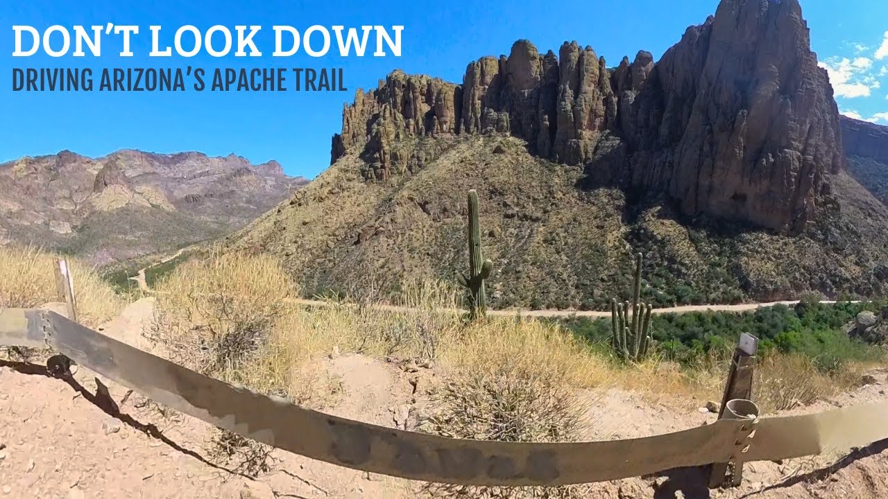
Once you survive Fish Creek Hill, the landscape starts to shift. The Superstition Mountains rise around you, their rocky peaks glowing in the afternoon sun.
The saguaros here are giants, some of them centuries old, their arms stretching toward the sky like they’re greeting old friends.
The road is remote, but it’s not empty.
Roadrunners dart across the dirt, too quick to catch in a photo. Ocotillo plants sway in the breeze, their spiny branches looking half-dead until the next good rain brings them back to life.

Apache Lake and a Taste of the Old West
After the intensity of Fish Creek Hill, the road smooths out near Apache Lake.
If someone asked you to imagine a desert oasis, this would be it. The deep blue water cuts through the rocky cliffs like a mirage, looking almost too perfect against the dry, rugged surroundings.
It’s the kind of place where you could sit for hours, watching the light change on the canyon walls.
A little farther down the road, we reached Tortilla Flat, a town with a population of six and the personality of an old Western movie set.
It started as a stagecoach stop and somehow survived the floods and fires that wiped out most of its original buildings. What’s there now looks historic, but most of it is a careful reconstruction.


The saloon is covered in dollar bills from past visitors, and the menu offers prickly pear gelato, which I seriously considered ordering until I saw the crowd spilling out onto the porch.
It was 111 degrees that day, and people were packed inside like it was the last place in Arizona with air conditioning.
I settled for a cold ginger ale in the Jeep and watched a family try to finish their melting gelato before it turned into pink syrup.

Need-to-Know Tips for Driving the Apache Trail
Planning on hitting the Apache Trail? Here are a few things to keep in mind to make sure your adventure goes smoothly.
- Start Early: The desert heat can be brutal. Start your day early to beat the worst of it and have more time to enjoy the scenery.
- Bring Water: The trail is remote, and you won’t find many places to stop for supplies. Be sure to pack enough water for the entire trip.
- Expect Rough Roads: The trail is part paved, part dirt and gravel. A high-clearance vehicle is your best bet for navigating the full 40-mile stretch. But don’t worry, the road is passable for most cars in certain areas.
- Check Road Conditions: Monsoon rains and rockslides can close sections of the road, so it’s worth checking current road conditions before you head out.
- Respect the Desert: The desert ecosystem is delicate. Leave no trace, stay on designated paths, and give wildlife plenty of space.
Why the Apache Trail is Worth the Drive
The Apache Trail isn’t just another scenic drive. It’s a place where the past still lingers.
You’re following the same path that stagecoaches, settlers, and Native American tribes once traveled, and while the road has been patched and repaired, it hasn’t been tamed.
The views are breathtaking, but this isn’t a leisurely Sunday drive. It’s the kind of road where you grip the wheel a little tighter, where every turn demands your full attention, and where the desert feels vast and untouchable in a way that’s hard to find anywhere else.
If you’re planning to drive the Apache Trail, start early to avoid the heat and the crowds. Bring plenty of water. ADOT recommends high-clearance vehicles for the full 40-mile trek, but aside from a few rough patches, the road was smooth enough for most cars.
The Apache Trail isn’t frozen in time. It’s still changing, still unpredictable, and still one of the most stunning drives in Arizona (f you’re up for it.)

Still Here? You Must Be the Human Equivalent of Well-Seasoned Cast Iron Pan.
Most people give up early, like tourists who underestimate the Arizona heat. But not you. You’re built differently. So why not join us for a camping chair on Substack?


